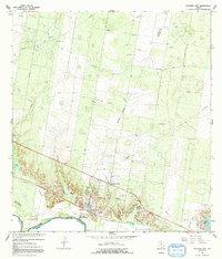
1965 Map of Sullivan City
USGS Topo · Published 1992About this map
The Rio Grande marks the international boundary between the United States and Mexico along the southern edge of this mid-1960s survey. Industrial activity defines much of the landscape, with the expansive Garcia Oil Field and numerous gravel pits indicating a resource-heavy economy. Local settlements like Sullivan City and Cuevitas are joined by the ranching outpost of El Toro Ranch, while the inclusion of the Santos Banco No 95 and Cuevitas Banco No 96 reflects the complex riparian history and land shifts of the river border. Community life is centered around local landmarks such as San Guillermo Ch and El Faro Sch, providing essential reference points for genealogists tracking family movements near the Starr and Hidalgo County line. The terrain transitions from the river valley to higher ground cut by Salado Creek and La Burrita Creek, revealing the natural drainage patterns that shaped early settlement.
Find a feature on this map
26 named features on this map. Tap any name to fly to it.
Don’t see what you’re looking for? This feature index may not catch every label — zoom into the map to look around manually.
Map Details
Editions of this 1965 Sullivan City Map
2 editions found
Other maps of this area

1940 · Monte Christo
USGS Topo · 1:62,500

1949 · Mc Allen
USGS Topo · 1:250,000

1954 · McAllen
USGS Topo · 1:250,000

1956 · Garcias
USGS Topo · 1:62,500

1956 · Los Ebanos
USGS Topo · 1:62,500

1957 · Mc Allen
USGS Topo · 1:250,000

1962 · McAllen
USGS Topo · 1:250,000

1963 · La Joya
USGS Topo · 1:24,000

1963 · Citrus City
USGS Topo · 1:24,000
1963 · McCook
USGS Topo · 1:24,000
Featured Places
- Sullivan City, TX
- La Grulla, TX
- Buena Vista Colonia, TX
- Vales Colonia, Sullivan City
- Benevides Colonia, Sullivan City