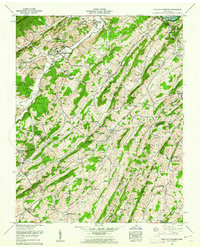
1959 Map of Sullivan Gardens
USGS Topo · Published 1962About this map
Bays Mtn and the Rocky Springs Ridge anchor this landscape, where the ridge-and-valley terrain of Northeast Tennessee dictates the flow of commerce and community. The South Fork Holston River is a primary focal point at the northern edge, dominated by the Fort Patrick Henry Dam and the rising waters of the Dolan Reservoir. This 1959 survey reveals the transition between established agrarian centers like Haws Crossroads and the expanding residential footprints of Colonial Heights and Sullivan Gardens. Family history is deeply etched into the land, with dozens of burial grounds such as McClellan Cem, Fulkerson Cem, and Bacon Cem located near longstanding landmarks like Kincheloe Mill. The presence of the Girl Scout Camp and Boys Scout Camp near the river indicates the mid-century emergence of the area as a destination for regional youth recreation.
Find a feature on this map
86 named features on this map. Tap any name to fly to it.
Don’t see what you’re looking for? This feature index may not catch every label — zoom into the map to look around manually.
Map Details
Editions of this 1959 Sullivan Gardens Map
3 editions found
Other maps of this area

1891 · Roan Mountain
USGS Topo · 1:125,000

1892 · Greeneville
USGS Topo · 1:125,000

1894 · Roan Mountain
USGS Topo · 1:125,000

1894 · Estillville
USGS Topo · 1:125,000

1896 · Greeneville
USGS Topo · 1:125,000

1897 · Bristol
USGS Topo · 1:125,000

1902 · Bristol
USGS Topo · 1:125,000

1904 · Roan Mountain
USGS Topo · 1:125,000

1904 · Greeneville
USGS Topo · 1:125,000

1935 · Lovelace
USGS Topo · 1:24,000