
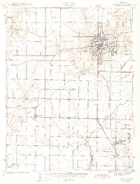
1943 Map of Sullivan
USGS Topo · Published 1943About this map
Sullivan serves as the bustling hub of this 1941 survey, showing the town's dense residential grid and industrial infrastructure during the early years of the Second World War. The map details a landscape deeply connected by rail, where the Illinois Central and Chicago and Eastern Illinois railroads intersect, facilitating the movement of goods through the Wabash Valley. Outside the main settlement, the area is punctuated by small rural communities like New Lebanon and Paxton, alongside numerous family-named landmarks that reflect generations of local settlement.
Find a feature on this map
34 named features on this map. Tap any name to fly to it.
Don’t see what you’re looking for? This feature index may not catch every label — zoom into the map to look around manually.
Map Details
Editions of this 1943 Sullivan Map
2 editions found
Other maps of this area

1917 · Birds
USGS Topo · 1:62,500

1942 · Fairbanks
USGS Topo · 1:24,000

1942 · Shelburn
USGS Topo · 1:24,000

1942 · Birds
USGS Topo · 1:62,500

1943 · Merom
USGS Topo · 1:24,000

1943 · Hymera
USGS Topo · 1:24,000

1943 · Carlisle
USGS Topo · 1:24,000

1943 · Dugger
USGS Topo · 1:24,000

1944 · Bucktown
USGS Topo · 1:24,000
1952 · Dugger
USGS Topo · 1:24,000