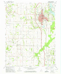
1974 Map of Sullivan
USGS Topo · Published 1975About this map
Sullivan serves as the focal point of this west-central Indiana survey, appearing as a developed county seat with a grid of landmark buildings including the Courthouse, Municipal Bldg, and Sherman Hospital. The landscape transitions from the urban center to an expansive agrarian layout, where the Illinois Central Gulf Railroad and the Louisville and Nashville lines provide critical transport infrastructure for the region's economy. The western portion of the map reveals active extraction with an Oil Field near the crossing of Illinois and Central roads.
Find a feature on this map
59 named features on this map. Tap any name to fly to it.
Don’t see what you’re looking for? This feature index may not catch every label — zoom into the map to look around manually.
Map Details
Editions of this 1974 Sullivan Map
2 editions found
Other maps of this area

1917 · Birds
USGS Topo · 1:62,500

1942 · Fairbanks
USGS Topo · 1:24,000

1942 · Shelburn
USGS Topo · 1:24,000

1942 · Birds
USGS Topo · 1:62,500

1943 · Merom
USGS Topo · 1:24,000

1943 · Hymera
USGS Topo · 1:24,000

1943 · Carlisle
USGS Topo · 1:24,000

1943 · Sullivan
USGS Topo · 1:24,000

1943 · Dugger
USGS Topo · 1:24,000

1944 · Bucktown
USGS Topo · 1:24,000