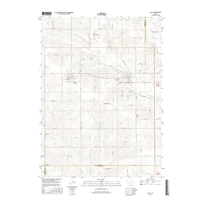
2015 Map of Sully
USGS Topo · Published 2015About this map
Sully and Lynnville serve as the primary hubs in this agricultural landscape within Jasper County during the mid-2010s. The region is defined by a rigorous grid of section-line roads, such as S 80th Ave E and E 146th St S, which navigate the drainages of the North Skunk River and Buckley Cr. The map reveals a high density of small burial grounds, including Swans Cem, Campbell Cem, and New Salem Cem, reflecting the early pioneer and denominational history of Lynn Grove Township. These cemeteries, often isolated along country roads like S 108th Ave E, provide significant anchor points for genealogical research in this part of Iowa. The presence of the Sully Municipal Airport just south of its namesake town marks the modern development of local infrastructure alongside traditional land use patterns.
Find a feature on this map
78 named features on this map. Tap any name to fly to it.
Don’t see what you’re looking for? This feature index may not catch every label — zoom into the map to look around manually.
Map Details
Editions of this 2015 Sully Map
This is the sole edition of this map. No revisions or reprints were ever made.
Other maps of this area

1910 · Pella
USGS Topo · 1:62,500

1912 · Pella
USGS Topo · 1:62,500

1954 · Des Moines
USGS Topo · 1:250,000

1956 · Des Moines
USGS Topo · 1:250,000

1957 · Des Moines
USGS Topo · 1:250,000

1969 · Des Moines
USGS Topo · 1:250,000

1979 · Searsboro
USGS Topo · 1:24,000

1979 · Grinnell South
USGS Topo · 1:24,000

1980 · Sully
USGS Topo · 1:24,000
1980 · Peoria
USGS Topo · 1:24,000