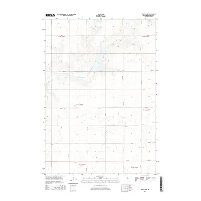
2015 Map of Sully Lake
USGS Topo · Published 2015About this map
Sully Lake serves as a central hydrological feature in this rural South Dakota landscape, collecting the waters of Okobojo Creek as it flows through the Great Plains. The map captures a highly organized section-line grid system, typical of the Missouri Plateau region, where roads like 183rd St and 301st Ave define the boundaries of large agricultural tracts. The terrain is characterized by the subtle drainage patterns of the Okobojo Creek valley, showing how the natural coulees and draws intersect with the rigid cadastral survey of Sully County. This 2015 edition provides a contemporary record of the land use and water management in a sparsely populated prairie environment, anchored by the namesake lake and the surrounding township and range divisions.
Find a feature on this map
23 named features on this map. Tap any name to fly to it.
Don’t see what you’re looking for? This feature index may not catch every label — zoom into the map to look around manually.
Map Details
Editions of this 2015 Sully Lake Map
This is the sole edition of this map. No revisions or reprints were ever made.
Other maps of this area

1954 · Pierre
USGS Topo · 1:250,000

1958 · Pierre
USGS Topo · 1:250,000

1965 · Artichoke Butte
USGS Topo · 1:24,000

1965 · Agar SW
USGS Topo · 1:24,000

1965 · Okobojo NE
USGS Topo · 1:24,000

1965 · Agar
USGS Topo · 1:24,000

1965 · Sully Lake
USGS Topo · 1:24,000

1967 · Onida SE
USGS Topo · 1:24,000

1967 · Onida SW
USGS Topo · 1:24,000
1967 · Okobojo SE
USGS Topo · 1:24,000