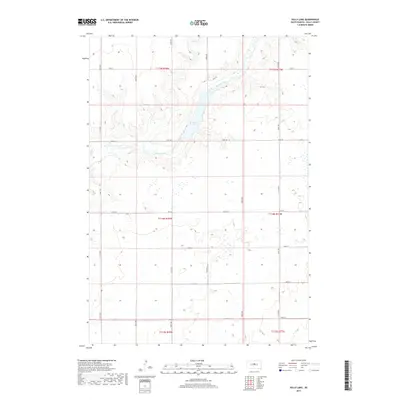
2017 Map of Sully Lake
USGS Topo · Published 2017About this map
Sully Lake and the meandering path of Okobojo Creek anchor this rural landscape in central South Dakota. The topography is defined by the carved valley of the creek as it winds through sections of Sully County, creating a distinct contrast to the surrounding high plains. The area is structured by a traditional section-line road grid, including Onida Rd and 187th St, which facilitate access across this agricultural territory. While the terrain is largely open, the drainage patterns around Okobojo Creek reveal the hydrological character of the region. This 2017 survey by the U.S. Geological Survey captures the modern configuration of local section lines and water bodies, providing a precise record of the land use and natural features that define this portion of the northern plains.
Find a feature on this map
22 named features on this map. Tap any name to fly to it.
Don’t see what you’re looking for? This feature index may not catch every label — zoom into the map to look around manually.
Map Details
Editions of this 2017 Sully Lake Map
This is the sole edition of this map. No revisions or reprints were ever made.
Other maps of this area

1954 · Pierre
USGS Topo · 1:250,000

1958 · Pierre
USGS Topo · 1:250,000

1965 · Artichoke Butte
USGS Topo · 1:24,000

1965 · Agar SW
USGS Topo · 1:24,000

1965 · Okobojo NE
USGS Topo · 1:24,000

1965 · Agar
USGS Topo · 1:24,000

1965 · Sully Lake
USGS Topo · 1:24,000

1967 · Onida SE
USGS Topo · 1:24,000

1967 · Onida SW
USGS Topo · 1:24,000
1967 · Okobojo SE
USGS Topo · 1:24,000