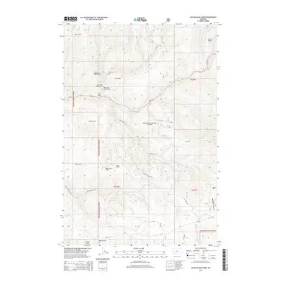
2014 Map of Sulphur Bar Creek
USGS Topo · Published 2014About this map
Helena National Forest dominates this landscape in eastern Broadwater County, where the Big Belt Mountains are dissected by a complex network of drainages. The map reveals a transition from high ridges like Windy Ridge and Grassy Mtn to the canyon floor of Deep Creek. This area is defined by its historical transit corridors, most notably the Flathead Indian Trail Road, which traces a path through the mountains south of Munding Flat. The drainage patterns are highly localized, with Sulphur Bar Creek and the various forks of Cabin Gulch illustrating how water has shaped the timbered terrain. This 2014 survey serves as a detailed record of Forest Service access and topographical landmarks, including named points like Black Butte and the winding course of US Highway 12 as it follows the creek beds toward the mountain passes.
Find a feature on this map
31 named features on this map. Tap any name to fly to it.
Don’t see what you’re looking for? This feature index may not catch every label — zoom into the map to look around manually.
Map Details
Editions of this 2014 Sulphur Bar Creek Map
This is the sole edition of this map. No revisions or reprints were ever made.
Other maps of this area

1886 · Fort Logan
USGS Topo · 1:250,000

1948 · White Sulphur Springs
USGS Topo · 1:250,000

1949 · Maudlow
USGS Topo · 1:62,500

1949 · Toston
USGS Topo · 1:62,500

1950 · Duck Creek Pass
USGS Topo · 1:62,500

1958 · White Sulphur Springs
USGS Topo · 1:250,000

1961 · White Sulphur Springs
USGS Topo · 1:250,000

1965 · White Sulphur Springs
USGS Topo · 1:250,000
1971 · Battle Mountain
USGS Topo · 1:24,000
1971 · Mount Edith
USGS Topo · 1:24,000