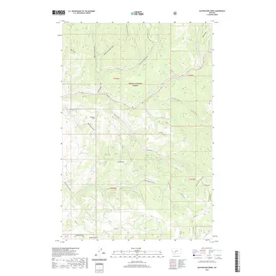
2020 Map of Sulphur Bar Creek
USGS Topo · Published 2020About this map
Helena National Forest dominates this mountain landscape in Broadwater and Meagher counties, where narrow gulches and high ridges define the drainage patterns. The topography is anchored by prominent elevations like Black Butte and Grassy Mtn, with Windy Ridge rising in the northeast. The hydraulic network is particularly complex here, featuring the headwaters of Deep Cr and its various tributaries, alongside Sulphur Bar Cr and Greyson Cr. A series of forest roads, including Sulphur Bar Rd and Ravenwood Ridge Rd, traverse the slopes, following the natural contours of the Big Belt Mountains. Historical movement through the area is reflected in the path of the Flathead Indian Trail Rd, which cuts across the central portion of the quadrangle. This 2020 map documents a landscape primarily used for timber, grazing, and watershed management, where locations like Munding Flat provide rare level ground amidst the steep terrain of Black Butte Gulch.
Find a feature on this map
33 named features on this map. Tap any name to fly to it.
Don’t see what you’re looking for? This feature index may not catch every label — zoom into the map to look around manually.
Map Details
Editions of this 2020 Sulphur Bar Creek Map
This is the sole edition of this map. No revisions or reprints were ever made.
Other maps of this area

1886 · Fort Logan
USGS Topo · 1:250,000

1948 · White Sulphur Springs
USGS Topo · 1:250,000

1949 · Maudlow
USGS Topo · 1:62,500

1949 · Toston
USGS Topo · 1:62,500

1950 · Duck Creek Pass
USGS Topo · 1:62,500

1958 · White Sulphur Springs
USGS Topo · 1:250,000

1961 · White Sulphur Springs
USGS Topo · 1:250,000

1965 · White Sulphur Springs
USGS Topo · 1:250,000
1971 · Battle Mountain
USGS Topo · 1:24,000
1971 · Mount Edith
USGS Topo · 1:24,000