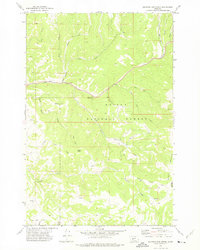
1971 Map of Sulphur Bar Creek
USGS Topo · Published 1975About this map
Helena National Forest encompasses the majority of this landscape, where the terrain is defined by a dense network of gulches and creek forks that feed into the larger basins. The historical Flathead Indian Trail cuts across the central and southern portions of the map, tracing a traditional route through the mountain passes. The presence of numerous unnamed springs and small drainages like Meyers Gulch and Miners Gulch suggests a landscape shaped by seasonal water flow and perhaps early prospecting activity.
Find a feature on this map
23 named features on this map. Tap any name to fly to it.
Don’t see what you’re looking for? This feature index may not catch every label — zoom into the map to look around manually.
Map Details
Editions of this 1971 Sulphur Bar Creek Map
This is the sole edition of this map. No revisions or reprints were ever made.
Other maps of this area

1886 · Fort Logan
USGS Topo · 1:250,000

1948 · White Sulphur Springs
USGS Topo · 1:250,000

1949 · Maudlow
USGS Topo · 1:62,500

1949 · Toston
USGS Topo · 1:62,500

1950 · Duck Creek Pass
USGS Topo · 1:62,500

1958 · White Sulphur Springs
USGS Topo · 1:250,000

1961 · White Sulphur Springs
USGS Topo · 1:250,000

1965 · White Sulphur Springs
USGS Topo · 1:250,000
1971 · Battle Mountain
USGS Topo · 1:24,000
1971 · Mount Edith
USGS Topo · 1:24,000