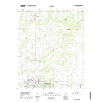
2018 Map of Sulphur North
USGS Topo · Published 2018About this map
The town of Sulphur anchors the southern portion of this landscape, where the grid of city streets meets the natural springs and creeks of the Chickasaw National Recreation Area. These water sources, including Antelope Spring and Buffalo Spring, feed into Travertine Creek, a system that defined the area's development as a regional destination. North of the town center, the terrain is characterized by a network of rural roads such as Dolberg Road and Caldwell Road, interspersed with smaller watercourses like Cochran Creek and Guy Sandy Creek. This rural-to-urban transition is marked by numerous family and community burial sites, including the Shirley Family Cemetery and Dolberg Baptist Cemetery, which provide valuable touchstones for genealogical research. The presence of the Sulphur Municipal Airport and the path of the Chickasaw Turnpike illustrate the modern transportation infrastructure overlaying this corner of Murray County.
Find a feature on this map
68 named features on this map. Tap any name to fly to it.
Don’t see what you’re looking for? This feature index may not catch every label — zoom into the map to look around manually.
Map Details
Editions of this 2018 Sulphur North Map
This is the sole edition of this map. No revisions or reprints were ever made.
Other maps of this area

1898 · Pauls Valley
USGS Topo · 1:125,000

1901 · Stonewall
USGS Topo · 1:125,000

1901 · Tishomingo
USGS Topo · 1:125,000

1901 · Ardmore
USGS Topo · 1:125,000

1902 · Pauls Valley
USGS Topo · 1:125,000

1918 · Ardmore
USGS Topo · 1:125,000

1957 · Ardmore
USGS Topo · 1:250,000

1963 · Ardmore
USGS Topo · 1:250,000

1963 · Sulphur South
USGS Topo · 1:24,000

1963 · Mill Creek
USGS Topo · 1:24,000