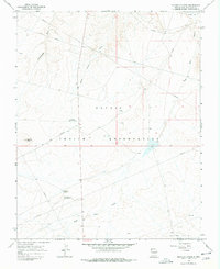
1966 Map of Sulphur Spring
USGS Topo · Published 1978About this map
Navajo Indian Reservation lands in San Juan County define this 1966 topographic study, where desert drainage systems like Rattlesnake Wash and Many Devils Wash carve through the arid plateau. The landscape is marked by the presence of the Table Mesa Oil Field at the southern boundary and numerous Oil Wells and Drill Hole sites scattered throughout, connected by an extensive network of pipelines.
Find a feature on this map
15 named features on this map. Tap any name to fly to it.
Don’t see what you’re looking for? This feature index may not catch every label — zoom into the map to look around manually.
Map Details
Editions of this 1966 Sulphur Spring Map
Other maps of this area

1889 · Chaco
USGS Topo · 1:250,000

1892 · Chaco
USGS Topo · 1:250,000

1927 · Sulphur Spring
USGS Topo · 1:96,000

1928 · Kirtland
USGS Topo · 1:125,000

1932 · Kirtland
USGS Topo · 1:125,000

1934 · Ship Rock
USGS Topo · 1:62,500

1934 · Chimney Rock
USGS Topo · 1:62,500

1934 · Rattlesnake
USGS Topo · 1:62,500

1936 · Chimney Rock
USGS Topo · 1:62,500

1937 · Ship Rock
USGS Topo · 1:62,500