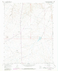
1966 Map of Sulphur Spring
USGS Topo · Published 1980About this map
The Navajo Indian Reservation landscape documented here in the mid-1960s reflects a balance between rugged desert topography and industrial utility. Resource extraction is evident throughout the terrain, particularly within the Table Mesa Oil Field where numerous Oil Well and Drill Hole markers dot the flats. Transportation through this arid region centers on the Red Rock Highway and a remote Landing Strip, providing essential access to isolated landmarks such as Cactus Peak. Water, though often ephemeral, is the primary sculptor of the land, evidenced by the extensive network of drainage systems including Rattlesnake Wash, Many Devils Wash, and Dead Mans Wash which feed toward the Chaco River. The presence of the Sulphur Spring Campground and Ship Rock Campground near Sulphur Spring suggests the area's significance for travelers and local community gatherings during this era.
Find a feature on this map
15 named features on this map. Tap any name to fly to it.
Don’t see what you’re looking for? This feature index may not catch every label — zoom into the map to look around manually.
Map Details
Editions of this 1966 Sulphur Spring Map
Other maps of this area

1889 · Chaco
USGS Topo · 1:250,000

1892 · Chaco
USGS Topo · 1:250,000

1927 · Sulphur Spring
USGS Topo · 1:96,000

1928 · Kirtland
USGS Topo · 1:125,000

1932 · Kirtland
USGS Topo · 1:125,000

1934 · Ship Rock
USGS Topo · 1:62,500

1934 · Chimney Rock
USGS Topo · 1:62,500

1934 · Rattlesnake
USGS Topo · 1:62,500

1936 · Chimney Rock
USGS Topo · 1:62,500

1937 · Ship Rock
USGS Topo · 1:62,500