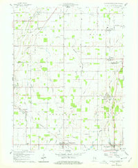
1960 Map of Sulphur Springs
USGS Topo · Published 1979About this map
The town of Sulphur Springs anchors this 1960 landscape along the border of Delaware and Henry Counties, serving as a hub for the surrounding agricultural townships of Jefferson, Prairie, and Salem. The region is defined by a dense network of small waterways and drainage runs, including Honey Creek, Fall Creek, and Sulphur Creek, which shaped the early settlement patterns of east-central Indiana. Small rural clusters like Progress and Cross Roads sit amongst a grid of county roads, while the villages of Springport and Oakville are positioned along the rail lines that facilitated the local grain and trade economy.
Find a feature on this map
45 named features on this map. Tap any name to fly to it.
Don’t see what you’re looking for? This feature index may not catch every label — zoom into the map to look around manually.
Map Details
Editions of this 1960 Sulphur Springs Map
4 editions found

Other maps of this area

1949 · New Castle West
USGS Topo · 1:24,000

1950 · New Castle East
USGS Topo · 1:24,000

1952 · Muncie East
USGS Topo · 1:24,000

1952 · Muncie West
USGS Topo · 1:24,000

1953 · Cincinnati
USGS Topo · 1:250,000

1953 · Muncie
USGS Topo · 1:250,000

1956 · Muncie
USGS Topo · 1:250,000

1957 · Cincinnati
USGS Topo · 1:250,000

1960 · Gilman
USGS Topo · 1:24,000

1960 · New Castle West
USGS Topo · 1:24,000