1985 Map of Sulphur Springs
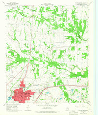
USGS Topo · Published 1985This historical map portrays the area of Sulphur Springs in 1985, primarily covering Hopkins County as well as portions of Wood County, Camp County, Fannin County, Red River County, Titus County, Franklin County, Hunt County, Delta County, and Lamar County. Featuring a scale of 1:100000, this map provides a highly detailed snapshot of the terrain, roads, buildings, counties, and historical landmarks in the Sulphur Springs region at the time. Published in 1985, it is the sole known edition of this map.
Find a feature on this map
167 named features on this map. Tap any name to fly to it.
Don’t see what you’re looking for? This feature index may not catch every label — zoom into the map to look around manually.
Map Details
Editions of this 1985 Sulphur Springs Map
This is the sole edition of this map. No revisions or reprints were ever made.
Historical Maps of Bogata Through Time
3 maps found