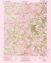
1973 Map of Sulphur Well
USGS Topo · Published 1984About this map
The Little Barren River and the South Fork Little Barren River meander through this 1970s landscape, shaping a terrain defined by rural settlements and religious centers. Community life is anchored by numerous small churches, including Pleasant Valley Ch, Antioch Ch, and Dripping Spring Ch, alongside the North Metcalfe Sch. Near Savoyard, the landscape shows clear evidence of local resource extraction with a sprawling Underground Gas Storage Field and numerous gas wells, indicating the industrial importance of the region's natural gas reserves.
Find a feature on this map
29 named features on this map. Tap any name to fly to it.
Don’t see what you’re looking for? This feature index may not catch every label — zoom into the map to look around manually.
Map Details
Editions of this 1973 Sulphur Well Map
2 editions found
Other maps of this area

1935 · Horse Cave
USGS Topo · 1:48,000

1938 · Horse Cave
USGS Topo · 1:62,500

1953 · Sulphur Well
USGS Topo · 1:24,000

1953 · Temple Hill
USGS Topo · 1:24,000

1953 · Edmonton
USGS Topo · 1:24,000

1953 · Summer Shade
USGS Topo · 1:24,000

1953 · Exie
USGS Topo · 1:24,000

1953 · Center
USGS Topo · 1:24,000

1953 · East Fork
USGS Topo · 1:24,000

1954 · Park
USGS Topo · 1:24,000