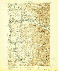
1923 Map of Sultan
USGS Topo · Published 1930About this map
Lumber RR lines and industrial sites dominate the landscape of the Cascade foothills in the early 1920s, tracing a period of heavy timber extraction and mining. The Sultan River and Skykomish River corridors serve as primary arteries for the Great Northern and Northern Pacific railroads, linking riverside settlements like Gold Bar and Startup. The mapping captures essential community infrastructure of the era, from the Mountain View School and Forest Glade School to the Reformatory near Monroe. To the east, the terrain rises sharply into the Snoqualmie National Forest, where the Apex Mines and the Coke Ovens at Snoqualmie indicate the region's diverse industrial roots. This survey preserves the dual identity of the region, where rural schoolhouses like Shady Grove School existed alongside the massive engineering of the C M & ST P RR and the Sultan Basin.
Find a feature on this map
106 named features on this map. Tap any name to fly to it.
Don’t see what you’re looking for? This feature index may not catch every label — zoom into the map to look around manually.
Map Details
Editions of this 1923 Sultan Map
4 editions found

Other maps of this area

1895 · Snohomish
USGS Topo · 1:125,000

1897 · Tacoma
USGS Topo · 1:125,000

1897 · Seattle
USGS Topo · 1:125,000

1899 · Glacier Peak
USGS Topo · 1:125,000

1899 · Stillaguamish
USGS Topo · 1:125,000

1900 · Tacoma
USGS Topo · 1:125,000

1901 · Glacier Peak
USGS Topo · 1:125,000

1901 · Stilaguamish
USGS Topo · 1:125,000

1901 · Snoqualmie Pass
USGS Topo · 1:125,000

1902 · Skykomish
USGS Topo · 1:125,000