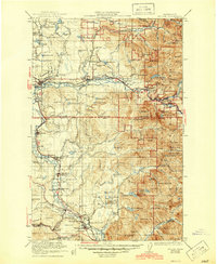
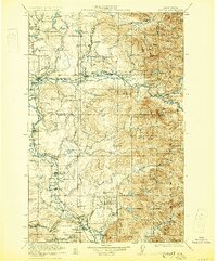
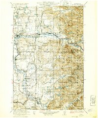
1923 Map of Sultan
USGS Topo · Published 1945About this map
The Great Northern RR and Northern Pacific RR anchor the industrial landscape of the Skykomish and Snoqualmie River valleys during the early 1920s. This survey reveals a region defined by timber and early resource extraction, featuring the Apex Mine and Coke Ovens near Snoqualmie Falls. Small rural communities are clearly visible, including the State Reformatory at Monroe and the settlement of Carnation Tolt PO. The map provides significant detail for genealogists, identifying numerous localized landmarks such as Forest Glade School, Shady Grove School, and remote outposts like Iowa Cabin and Lone Pine Cabin. Dramatic elevation changes are marked by Wallace Falls and Bridalveil Falls, while the transition from developed valley floors to the high peaks of the Snoqualmie National Forest is well-documented.
Find a feature on this map
138 named features on this map. Tap any name to fly to it.
Don’t see what you’re looking for? This feature index may not catch every label — zoom into the map to look around manually.
Map Details
Editions of this 1923 Sultan Map
4 editions found

Other maps of this area

1895 · Snohomish
USGS Topo · 1:125,000

1897 · Tacoma
USGS Topo · 1:125,000

1897 · Seattle
USGS Topo · 1:125,000

1899 · Glacier Peak
USGS Topo · 1:125,000

1899 · Stillaguamish
USGS Topo · 1:125,000

1900 · Tacoma
USGS Topo · 1:125,000

1901 · Glacier Peak
USGS Topo · 1:125,000

1901 · Stilaguamish
USGS Topo · 1:125,000

1901 · Snoqualmie Pass
USGS Topo · 1:125,000

1902 · Skykomish
USGS Topo · 1:125,000