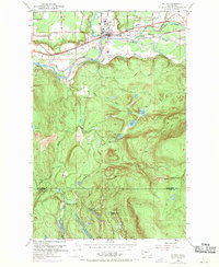
1953 Map of Sultan
USGS Topo · Published 1969About this map
Sultan serves as the focal point of this mid-century survey, positioned at the confluence of the Sultan River and the Skykomish River. The town's infrastructure in the early 1950s is defined by the Great Northern railroad and several arterial routes, including Lake Chaplain Road and the Sultan Basin Rd. North of the town center, a Landing Strip and a Trailer Park illustrate the local transit and residential patterns of the post-war era.
Find a feature on this map
38 named features on this map. Tap any name to fly to it.
Don’t see what you’re looking for? This feature index may not catch every label — zoom into the map to look around manually.
Map Details
Editions of this 1953 Sultan Map
4 editions found
Other maps of this area

1921 · Sultan
USGS Topo · 1:125,000

1923 · Sultan
USGS Topo · 1:125,000

1953 · Sultan
USGS Topo · 1:24,000

1953 · Lake Joy
USGS Topo · 1:24,000

1953 · Monroe
USGS Topo · 1:24,000

1953 · Carnation
USGS Topo · 1:24,000

1956 · Monroe
USGS Topo · 1:62,500

1957 · Index
USGS Topo · 1:62,500

1957 · Wenatchee
USGS Topo · 1:250,000

1960 · Mount Si
USGS Topo · 1:62,500