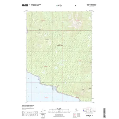
2017 Map of Sumdum A-5 NE
USGS Topo · Published 2017About this map
Frederick Sound defines the southern coastline of this remote Petersburg Borough landscape, where the tides meet the steep slopes of the Coast Mountains. The interior is dominated by the sprawling Tongass National Forest, a wilderness of high summits including Mt Fanshaw and the Fanshaw Range. The terrain rises sharply from the saltwater to several prominent markers used by mariners and aviators alike, such as Point Highland and the distinctly named Man-of-War Peak. Small drainage systems like Cat Cr and Negra Cr carve narrow paths through the heavy timber and high-elevation contours. This survey illustrates the relationship between the dramatic coastal topography and the inland peaks, including Dahlgren Peak and Jamestown Peak, which stand as significant landmarks within the federal forest boundaries.
Find a feature on this map
18 named features on this map. Tap any name to fly to it.
Don’t see what you’re looking for? This feature index may not catch every label — zoom into the map to look around manually.
Map Details
Editions of this 2017 Sumdum A-5 NE Map
This is the sole edition of this map. No revisions or reprints were ever made.
Other maps of this area

1943 · Sumdum B-4
USGS Topo · 1:63,360

1948 · Sumdum A-4
USGS Topo · 1:63,360

1948 · Sumdum A-5
USGS Topo · 1:63,360

1948 · Sumdum B-5
USGS Topo · 1:63,360

1948 · Sumdum B-4
USGS Topo · 1:63,360

1951 · Sumdum A-4
USGS Topo · 1:63,360

1951 · Sumdum B-5
USGS Topo · 1:63,360

1952 · Sumdum
USGS Topo · 1:250,000

1961 · Sumdum
USGS Topo · 1:250,000

1996 · Sumdum B-4
USGS Topo · 1:63,360