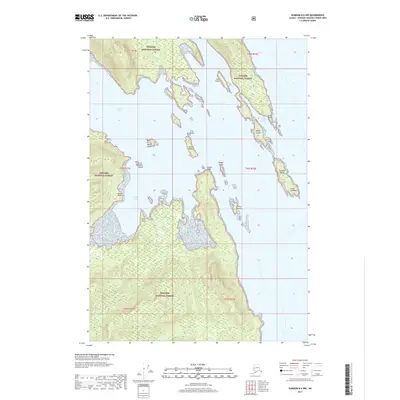
2017 Map of Sumdum B-6 NW
USGS Topo · Published 2017About this map
The Tongass National Forest dominates this coastal landscape, where the tides of Southeast Alaska meet a complex network of islands and inlets. Marine navigation is central to the area, defined by the protected waters of Gambier Bay and the smaller reach of Last Chance Harbor tucked behind Grunt Point. The map reveals a shore defined by descriptive maritime landmarks, such as Church Point and Chapel Island, which likely served as visual waypoints for vessels traversing these coastal passages. Along the western edge, the coastline is punctuated by Scald Point and the sheltered Snug Cove, illustrating the importance of natural harbors in this roadless wilderness. The distribution of small landmasses like Muse Island, Gain Island, and Romp Island across the bay reflects a fractured geography where the forest meets the sea at every turn.
Find a feature on this map
24 named features on this map. Tap any name to fly to it.
Don’t see what you’re looking for? This feature index may not catch every label — zoom into the map to look around manually.
Map Details
Editions of this 2017 Sumdum B-6 NW Map
This is the sole edition of this map. No revisions or reprints were ever made.
Other maps of this area

1948 · Sitka B-1
USGS Topo · 1:63,360

1948 · Sitka C-1
USGS Topo · 1:63,360

1948 · Sumdum B-6
USGS Topo · 1:63,360

1948 · Sumdum C-6
USGS Topo · 1:63,360

1951 · Sitka
USGS Topo · 1:250,000

1951 · Sitka C-1
USGS Topo · 1:63,360

1951 · Sitka B-1
USGS Topo · 1:63,360

1951 · Sumdum C-6
USGS Topo · 1:63,360

1952 · Sumdum
USGS Topo · 1:250,000

1952 · Sitka
USGS Topo · 1:250,000