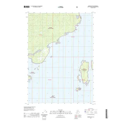
2021 Map of Sumdum B-6 SW
USGS Topo · Published 2021About this map
Tongass National Forest dominates the coastal landscape of this quadrangle, where the intricate shoreline of Pybus Bay meets the open waters of Frederick Sound. The geography is defined by prominent headlands such as False Point Pybus, Square Point, and Point Pybus, which mark the transition from the forested interior to the sea. Offshore, the San Juan Islands and the solitary West Brother Island rise from the sound, illustrating the archipelago character of this maritime wilderness. Farther south, the isolated Round Rock sits within the maritime boundary, serving as a distinct navigational landmark. This survey provides a precise view of the coastal topography and township boundaries as they existed in the early 21st century, revealing the primitive, undeveloped nature of these protected lands within the Unorganized Borough.
Find a feature on this map
13 named features on this map. Tap any name to fly to it.
Don’t see what you’re looking for? This feature index may not catch every label — zoom into the map to look around manually.
Map Details
Editions of this 2021 Sumdum B-6 SW Map
This is the sole edition of this map. No revisions or reprints were ever made.
Other maps of this area

1948 · Sitka B-1
USGS Topo · 1:63,360

1948 · Sumdum A-6
USGS Topo · 1:63,360

1948 · Sumdum B-6
USGS Topo · 1:63,360

1948 · Sitka A-1
USGS Topo · 1:63,360

1951 · Sitka
USGS Topo · 1:250,000

1951 · Sitka B-1
USGS Topo · 1:63,360

1952 · Sumdum
USGS Topo · 1:250,000

1952 · Sitka
USGS Topo · 1:250,000

1961 · Sumdum
USGS Topo · 1:250,000

1964 · Sitka
USGS Topo · 1:250,000