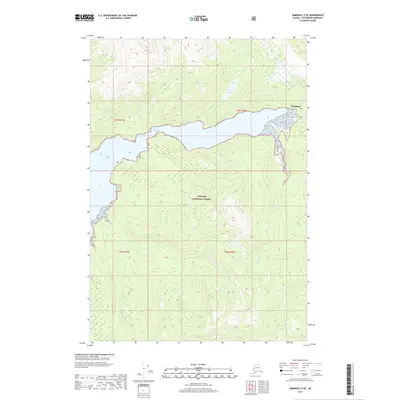
2017 Map of Sumdum C-5 SE
USGS Topo · Published 2017About this map
Windham sits at the head of a long, deep-water inlet within the Tongass National Forest, illustrating the maritime-dependent settlement patterns of Southeast Alaska. This coastal landscape is dominated by the tidal reach of Windham Bay, which constricts at The Narrows before opening into a sheltered inner basin. The drainage network is dense, with Taylor Cr flowing from Taylor Lake to the north, while the Chuck River and Spruce Creek enter the bay from the eastern timberlands. The terrain is defined by steep elevation changes typical of the region's fjords, with several other watercourses like Sylvia Cr and Slate Cr carving through the surrounding forest. The map provides a look at the interplay between the Pacific coastline and the vast national forest interior during the early 21st century.
Find a feature on this map
14 named features on this map. Tap any name to fly to it.
Don’t see what you’re looking for? This feature index may not catch every label — zoom into the map to look around manually.
Map Details
Editions of this 2017 Sumdum C-5 SE Map
This is the sole edition of this map. No revisions or reprints were ever made.
Other maps of this area

1943 · Sumdum B-4
USGS Topo · 1:63,360

1948 · Sumdum C-5
USGS Topo · 1:63,360

1948 · Sumdum B-5
USGS Topo · 1:63,360

1948 · Sumdum B-4
USGS Topo · 1:63,360

1951 · Sumdum C-5
USGS Topo · 1:63,360

1951 · Sumdum B-5
USGS Topo · 1:63,360

1952 · Sumdum
USGS Topo · 1:250,000

1961 · Sumdum C-4
USGS Topo · 1:63,360

1961 · Sumdum
USGS Topo · 1:250,000

1996 · Sumdum B-4
USGS Topo · 1:63,360