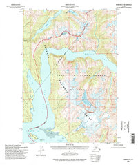
1994 Map of Sumdum D-5
USGS Topo · Published 1998About this map
The Tracy Arm - Fords Terror Wilderness dominates this landscape, where deep glacial fjords meet the steep rises of the Tongass National Forest. The map documents a dramatic coastal interface along Tracy Arm and Endicott Arm, converging at the head of Holkham Bay. This 1994 revision, based on mid-century topography and 1990s imagery, preserves the site of Indian Village (Aban'd) on the northern shore of Endicott Arm, a rare indicator of human occupation in an area otherwise defined by raw natural processes.
Find a feature on this map
24 named features on this map. Tap any name to fly to it.
Don’t see what you’re looking for? This feature index may not catch every label — zoom into the map to look around manually.
Map Details
Editions of this 1994 Sumdum D-5 Map
This is the sole edition of this map. No revisions or reprints were ever made.
Other maps of this area

1948 · Sumdum D-6
USGS Topo · 1:63,360

1948 · Sumdum C-5
USGS Topo · 1:63,360

1948 · Sumdum C-6
USGS Topo · 1:63,360

1948 · Sumdum D-5
USGS Topo · 1:63,360

1951 · Taku River A-4
USGS Topo · 1:63,360

1951 · Taku River A-5
USGS Topo · 1:63,360

1951 · Taku River A-6
USGS Topo · 1:63,360

1951 · Sumdum C-5
USGS Topo · 1:63,360

1951 · Sumdum D-6
USGS Topo · 1:63,360

1951 · Sumdum C-6
USGS Topo · 1:63,360