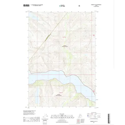
2017 Map of Sumdum D-5 NE
USGS Topo · Published 2017About this map
Tracy Arm cuts through the glaciated terrain of this coastal wilderness, serving as the dominant geographic feature within the Tongass National Forest. The map documents a rugged landscape where steep elevation changes are interrupted by significant water bodies such as Upper Sweetheart Lake to the north and the aptly named Icefall Lake further south. These lakes are connected to the fjord systems by drainage features like Sweetheart Cr, illustrating the complex hydrological network of the Alaskan panhandle.
Find a feature on this map
10 named features on this map. Tap any name to fly to it.
Don’t see what you’re looking for? This feature index may not catch every label — zoom into the map to look around manually.
Map Details
Editions of this 2017 Sumdum D-5 NE Map
This is the sole edition of this map. No revisions or reprints were ever made.
Other maps of this area

1948 · Sumdum D-5
USGS Topo · 1:63,360

1951 · Taku River A-4
USGS Topo · 1:63,360

1951 · Taku River A-5
USGS Topo · 1:63,360

1952 · Sumdum
USGS Topo · 1:250,000

1953 · Taku River
USGS Topo · 1:250,000

1955 · Sumdum D-5
USGS Topo · 1:63,360

1960 · Taku River
USGS Topo · 1:250,000

1960 · Sumdum D-4
USGS Topo · 1:63,360

1961 · Sumdum
USGS Topo · 1:250,000
1994 · Sumdum D-5
USGS Topo · 1:63,360