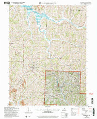
2002 Map of Summerfield
USGS Topo · Published 2006About this map
Summerfield serves as the primary hub of activity in this pocket of Southeast Ohio, situated along the spine of Lexington Ridge. The landscape is defined by the intersection of rural agriculture and natural resource extraction, with a visible Strip Mine and Quarry dotting the hillsides near Doherty and Ethel. To the north, the waters of Senecaville Lake reach into the quadrangle, managed by the Muskingum Watershed Conservancy District.
Find a feature on this map
48 named features on this map. Tap any name to fly to it.
Don’t see what you’re looking for? This feature index may not catch every label — zoom into the map to look around manually.
Map Details
Editions of this 2002 Summerfield Map
This is the sole edition of this map. No revisions or reprints were ever made.
Other maps of this area

1903 · Macksburg
USGS Topo · 1:62,500

1905 · New Matamoras
USGS Topo · 1:62,500

1905 · Woodsfield
USGS Topo · 1:62,500

1905 · Macksburg
USGS Topo · 1:62,500

1909 · Summerfield
USGS Topo · 1:62,500

1911 · Summerfield
USGS Topo · 1:62,500

1924 · New Matamoras
USGS Topo · 1:62,500

1926 · New Matamoras
USGS Topo · 1:62,500

1949 · Clarksburg
USGS Topo · 1:250,000

1956 · Clarksburg
USGS Topo · 1:250,000