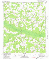
1980 Map of Summerlins Crossroads
USGS Topo · Published 1980About this map
Goshen Swamp and Nahunga Creek dominate this low-lying stretch of Duplin County, where a network of crossroads settlements defined rural life in the late 1970s. This survey identifies numerous pocket communities such as Summerlins Crossroads, Hills Crossroads, and Westbrook Crossroads, each serving as a focal point for the surrounding farms. The landscape is heavily marked by small family and community burial grounds, including the Pate Cem and Alum Springs Cem, alongside numerous country churches like Bethel Ch and Smith Chapel.
Find a feature on this map
61 named features on this map. Tap any name to fly to it.
Don’t see what you’re looking for? This feature index may not catch every label — zoom into the map to look around manually.
Map Details
Editions of this 1980 Summerlins Crossroads Map
This is the sole edition of this map. No revisions or reprints were ever made.
Other maps of this area

1943 · Kenansville
USGS Topo · 1:62,500

1948 · Kenansville
USGS Topo · 1:62,500

1953 · Florence
USGS Topo · 1:250,000

1953 · Rocky Mount
USGS Topo · 1:250,000

1953 · Raleigh
USGS Topo · 1:250,000

1953 · Beaufort
USGS Topo · 1:250,000

1954 · Rocky Mount
USGS Topo · 1:250,000

1954 · Florence
USGS Topo · 1:250,000

1954 · Raleigh
USGS Topo · 1:250,000

1954 · Beaufort
USGS Topo · 1:250,000