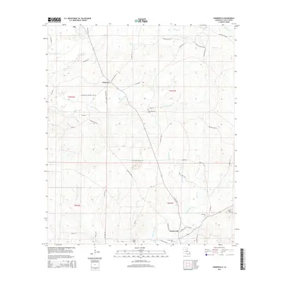
2015 Map of Summerville
USGS Topo · Published 2015About this map
Chickasaw and Summerville anchor this central LaSalle Parish landscape, where the traditional timber and hunting lands are mapped alongside modern industrial developments. The terrain is defined by a dense network of watercourses, most notably the winding path of Bayou Funny Louis and its various tributaries like Little Chickasaw Cr and Jumping Gully Cr. Several small family and community burial sites, such as Little Chickasaw Cem and Squires Cem, are scattered across the quadrangle, providing critical touchstones for genealogists researching local heritage.
Find a feature on this map
56 named features on this map. Tap any name to fly to it.
Don’t see what you’re looking for? This feature index may not catch every label — zoom into the map to look around manually.
Map Details
Editions of this 2015 Summerville Map
This is the sole edition of this map. No revisions or reprints were ever made.
Other maps of this area

1936 · Pollock
USGS Topo · 1:62,500

1941 · Jena
USGS Topo · 1:62,500

1941 · Pollock
USGS Topo · 1:62,500

1953 · Alexandria
USGS Topo · 1:250,000

1954 · Tullos
USGS Topo · 1:62,500

1955 · Alexandria
USGS Topo · 1:250,000

1955 · Olla
USGS Topo · 1:62,500

1958 · Pollock
USGS Topo · 1:62,500

1958 · Jena
USGS Topo · 1:62,500
1984 · Summerville
USGS Topo · 1:24,000