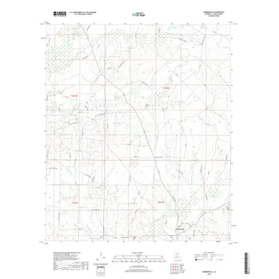
2018 Map of Summerville
USGS Topo · Published 2018About this map
Summerville anchors the southeast corner of this central Louisiana landscape, where the mixed pine and hardwood forests of LaSalle Parish are defined by an intricate network of creeks and bayous. The settlement pattern is largely shaped by the meandering Bayou Funny Louis and its various tributaries, including Mill Cr and Safety Cr. For those tracing local history, several burial grounds are scattered throughout the region, such as Summerville Cem, Squires Cem, and Little Chickasaw Cem. The landscape reveals a complex system of utility and industry-oriented roads, including Oil Field Rd, Pleasant Ridge Rd, and Landfill Rd, which cut across the varied drainage basins of Chickasaw Cr and Jumping Gully Cr. This survey illustrates the persistence of small rural communities and the essential role of the local waterway system in defining land boundaries and travel routes.
Find a feature on this map
72 named features on this map. Tap any name to fly to it.
Don’t see what you’re looking for? This feature index may not catch every label — zoom into the map to look around manually.
Map Details
Editions of this 2018 Summerville Map
This is the sole edition of this map. No revisions or reprints were ever made.
Other maps of this area

1936 · Pollock
USGS Topo · 1:62,500

1941 · Jena
USGS Topo · 1:62,500

1941 · Pollock
USGS Topo · 1:62,500

1953 · Alexandria
USGS Topo · 1:250,000

1954 · Tullos
USGS Topo · 1:62,500

1955 · Alexandria
USGS Topo · 1:250,000

1955 · Olla
USGS Topo · 1:62,500

1958 · Pollock
USGS Topo · 1:62,500

1958 · Jena
USGS Topo · 1:62,500
1984 · Summerville
USGS Topo · 1:24,000