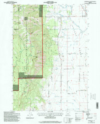
1996 Map of Summerville
USGS Topo · Published 1998About this map
The eastern edge of the Grande Ronde Valley meets the high elevations of the Wallowa-Whitman National Forest in this survey of northern Union County. The settlement of Summerville serves as the focal point for a landscape defined by an organized grid of ranch roads and irrigation infrastructure, including the Ordell Ditch. To the west, the terrain rises sharply toward Mount Emily, where deep drainage systems like Rail Canyon and Bull Canyon carve through the timber. Local community life is anchored by landmarks such as the Pleasant Grove Grange Hall and the Pioneer Monument, reflecting the area's long agricultural heritage. Between the flat valley floor and the high ridgelines of Burnt Ridge and Herron Ridge, the map captures a transition from intensive farming to the timbered reaches of the Blue Mountains.
Find a feature on this map
52 named features on this map. Tap any name to fly to it.
Don’t see what you’re looking for? This feature index may not catch every label — zoom into the map to look around manually.
Map Details
Editions of this 1996 Summerville Map
This is the sole edition of this map. No revisions or reprints were ever made.
Other maps of this area

1906 · Telocaset
USGS Topo · 1:125,000

1953 · Pendleton
USGS Topo · 1:250,000

1955 · Grangeville
USGS Topo · 1:250,000

1956 · Pendleton
USGS Topo · 1:250,000

1959 · Grangeville
USGS Topo · 1:250,000

1963 · La Grande SE
USGS Topo · 1:24,000

1963 · Sanderson Spring
USGS Topo · 1:24,000

1963 · Hilgard
USGS Topo · 1:24,000

1963 · Summerville
USGS Topo · 1:24,000

1964 · Thimbleberry Mtn
USGS Topo · 1:24,000