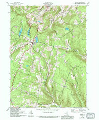
1943 Map of Summit
USGS Topo · Published 1994About this map
Summit sits as the central hub of this northern Appalachian landscape, where the headwaters of several drainages diverge across the town lines of Fulton and Jefferson. The terrain is defined by a series of deep cuts including Wharton Hollow, Beards Hollow, and Dibble Hollow, which funnel water into larger systems like Wharton Creek and Panther Creek. This geography created a decentralized settlement pattern, with small clusters like Eminence and Vroman Corners established in the more accessible valley floors.
Find a feature on this map
33 named features on this map. Tap any name to fly to it.
Don’t see what you’re looking for? This feature index may not catch every label — zoom into the map to look around manually.
Map Details
Editions of this 1943 Summit Map
4 editions found

Other maps of this area

1898 · Schoharie
USGS Topo · 1:62,500

1900 · Schoharie
USGS Topo · 1:62,500

1901 · Gilboa
USGS Topo · 1:62,500

1903 · Gilboa
USGS Topo · 1:62,500

1904 · Richmondville
USGS Topo · 1:62,500

1904 · Hobart
USGS Topo · 1:62,500

1943 · Cobleskill
USGS Topo · 1:24,000

1943 · South Valley
USGS Topo · 1:24,000

1943 · Breakabeen
USGS Topo · 1:24,000

1943 · Charlotteville
USGS Topo · 1:24,000