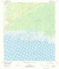
1955 Map of Sumner
USGS Topo · Published 1984About this map
Rosewood and Sumner anchor the northern landscape of this coastal survey, where the terrestrial forests of Gulf Hammock meet the intricate tidal networks of the Florida coastline. The area is defined by a maze of salt marshes and tidal creeks such as Porpoise Creek, Wilder Creek, and King Creek, which drain into the shallow waters of Waccasassa Bay. In the higher, drier ground to the north, the Suwannee Lookout Tower and Turkey Field stand as landmarks within the timbered terrain. Historically significant sites like Shiloh Cem are preserved on the map, providing essential location data for genealogists. The southern portion of the sheet transitions into the open Gulf of Mexico, marked by maritime hazards and natural features including Corrigan Reef and Waccasassa Reefs, illustrating the transition from the Big Bend's low-lying hammocks to the Gulf's limestone reef systems.
Find a feature on this map
32 named features on this map. Tap any name to fly to it.
Don’t see what you’re looking for? This feature index may not catch every label — zoom into the map to look around manually.
Map Details
Editions of this 1955 Sumner Map
4 editions found
Other maps of this area

1954 · Otter Creek
USGS Topo · 1:24,000

1954 · Chiefland SW
USGS Topo · 1:24,000

1954 · East Pass
USGS Topo · 1:24,000

1954 · Gainesville
USGS Topo · 1:250,000

1955 · Seahorse Key
USGS Topo · 1:24,000

1955 · Cedar Key
USGS Topo · 1:24,000

1955 · Withlacoochee Bay
USGS Topo · 1:24,000

1955 · Waccasassa Bay
USGS Topo · 1:24,000

1955 · Sumner
USGS Topo · 1:24,000

1958 · Gainesville
USGS Topo · 1:250,000