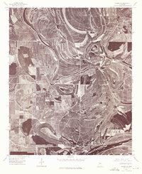
1974 Map of Sumner SE
USGS Topo · Published 1975About this map
Glendora and Minter City anchor this orthophotoquad, which reveals the complex agricultural geometry of the Mississippi Delta in the mid-1970s. The landscape is defined by the sinuous path of the River as it meanders through vast cultivated fields, creating sharp oxbows and distinctive meander scars that speak to the region's long history of alluvial shifting. Unlike traditional topographic maps, this aerial perspective provides a clear view of woodlots and forest fragments preserved in the bends of the water, contrasting with the expansive, grid-like clearing of the surrounding bottomlands. The image captures the rural footprint of these small settlements at a time when the region's plantation heritage was transitioning into large-scale mechanized farming, showing the relationship between historical water routes and modern land use.
Find a feature on this map
3 named features on this map. Tap any name to fly to it.
Don’t see what you’re looking for? This feature index may not catch every label — zoom into the map to look around manually.
Map Details
Editions of this 1974 Sumner SE Map
This is the sole edition of this map. No revisions or reprints were ever made.
Other maps of this area

1931 · Schlater
USGS Topo · 1:48,000

1931 · Sumner
USGS Topo · 1:48,000

1932 · Philipp
USGS Topo · 1:48,000

1934 · Schlater
USGS Topo · 1:62,500

1935 · Sumner
USGS Topo · 1:62,500

1935 · Philipp
USGS Topo · 1:62,500

1936 · Greenwood
USGS Topo · 1:62,500

1939 · Schlater
USGS Topo · 1:62,500

1939 · Sumner
USGS Topo · 1:62,500

1939 · Philipp
USGS Topo · 1:62,500