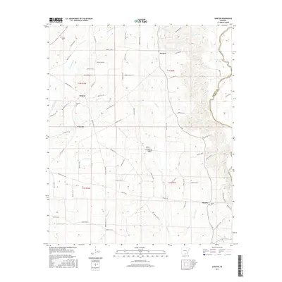
2017 Map of Sumpter
USGS Topo · Published 2017About this map
The Saline River forms a natural eastern boundary in this Bradley County landscape, where the rural settlements of Sumpter, Mount Olive, and Simpson are connected by a network of county roads. The terrain is defined by a series of south-flowing drainages including Snake Creek and Beech Creek, which carve through the timbered hills. For those researching local families, the map identifies several congregational centers and burial grounds, such as Mount Olive Cemetery and Pattsville Cemetery. The area south of Pattsville shows a transition into the more marshy lowlands near Halfway Creek, while the eastern edge near Smearny traces the river's winding path against the Drew County line. This 2017 survey reflects the persistent character of these small Arkansas communities, highlighting how historic place names like Simpson remain fixed on the landscape even as local infrastructure evolves.
Find a feature on this map
74 named features on this map. Tap any name to fly to it.
Don’t see what you’re looking for? This feature index may not catch every label — zoom into the map to look around manually.
Map Details
Editions of this 2017 Sumpter Map
This is the sole edition of this map. No revisions or reprints were ever made.
Other maps of this area

1934 · Ingalls
USGS Topo · 1:48,000

1937 · Ingalls
USGS Topo · 1:62,500

1939 · Ingalls
USGS Topo · 1:62,500

1953 · Greenwood
USGS Topo · 1:250,000

1953 · El Dorado
USGS Topo · 1:250,000

1956 · Greenwood
USGS Topo · 1:250,000

1957 · El Dorado
USGS Topo · 1:250,000

1958 · El Dorado
USGS Topo · 1:250,000

1960 · El Dorado
USGS Topo · 1:250,000
1971 · Vick
USGS Topo · 1:24,000