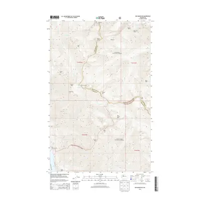
2014 Map of Sun Mountain
USGS Topo · Published 2014About this map
Lake Chelan anchors the southwestern edge of this high-elevation terrain, where the Lucerne-Stehekin Ferry route provides a vital waterborne connection through the wilderness. The landscape is a complex of significant peaks and ridgelines, including Reynolds Peak, Splawn Mtn, and the prominent War Creek Ridge. This area serves as a critical boundary zone between the Okanogan National Forest and the Wenatchee National Forest, with the county line between Chelan and Okanogan following the high divides. Backcountry travelers rely on strategic crossings like War Creek Pass and Purple Pass to navigate between deep drainages such as Fourmile Cr and Flick Cr. The presence of the Flick Creek Campground near Hunts Bluff highlights the recreational value of the shoreline in this protected mountain corridor.
Find a feature on this map
45 named features on this map. Tap any name to fly to it.
Don’t see what you’re looking for? This feature index may not catch every label — zoom into the map to look around manually.
Map Details
Editions of this 2014 Sun Mountain Map
This is the sole edition of this map. No revisions or reprints were ever made.
Other maps of this area

1899 · Methow
USGS Topo · 1:125,000

1901 · Methow
USGS Topo · 1:125,000

1902 · Stehekin
USGS Topo · 1:125,000

1904 · Stehekin
USGS Topo · 1:125,000

1944 · Lucerne
USGS Topo · 1:62,500

1949 · Lucerne
USGS Topo · 1:62,500

1955 · Concrete
USGS Topo · 1:250,000

1958 · Concrete
USGS Topo · 1:250,000

1962 · Concrete
USGS Topo · 1:250,000
1969 · Midnight Mtn.
USGS Topo · 1:24,000