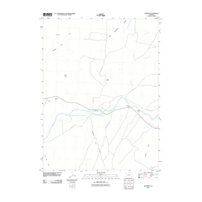
2010 Map of Sunbeam
USGS Topo · Published 2010About this map
Sunbeam anchors this high-desert landscape in Northwest Colorado where the Yampa River carves through a series of significant geographic formations. The settlement lies at the intersection of rural transit routes, serving as a gateway to the high plateaus of Peck Mesa and the prominent heights of Bald Mountain. The irrigation infrastructure of the Maybell Ditch is clearly visible, reflecting the vital role of water management in this arid ranching and range country. To the north, the dramatic Godiva Rim and the Suttles Basin define the horizon, while local history is etched into landmarks like Indian Rock and the livestock-friendly terrain of Boston Flat. The intricate network of drainage systems, including Thornburg Draw and Lone Tree Gulch, illustrates the complex topography that has shaped the region's agricultural and land-use history into the twenty-first century.
Find a feature on this map
23 named features on this map. Tap any name to fly to it.
Don’t see what you’re looking for? This feature index may not catch every label — zoom into the map to look around manually.
Map Details
Editions of this 2010 Sunbeam Map
This is the sole edition of this map. No revisions or reprints were ever made.
Other maps of this area

1907 · White River
USGS Topo · 1:125,000

1910 · White River
USGS Topo · 1:125,000

1954 · Vernal
USGS Topo · 1:250,000

1958 · Vernal
USGS Topo · 1:250,000

1958 · Maybell
USGS Topo · 1:62,500

1958 · Citadel Plateau
USGS Topo · 1:62,500

1960 · Vernal
USGS Topo · 1:250,000

1960 · Elk Springs
USGS Topo · 1:62,500

1960 · Lone Mountain
USGS Topo · 1:62,500
1979 · Rangely
USGS Topo · 1:100,000