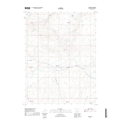
2019 Map of Sunbeam
USGS Topo · Published 2019About this map
The Yampa River serves as the primary lifeblood of this arid Moffat County landscape, flowing through a broad valley anchored by the small settlement of Sunbeam. This 2019 survey illustrates a complex system of water management and natural drainage, where the Maybell Ditch diverts water along the river's southern bank near Boston Flat. The terrain is defined by dramatic elevation changes, from the prominent Godiva Rim in the north to the distinctive landmarks of Indian Rock and Peck Mesa. Local history is etched into the names of the drainage basins and springs, such as Thornburg Draw, Simsberry Draw, and Brouse Spring, which point to the ranching and pioneer heritage of northwestern Colorado. The grid of county roads, including Co RD 10 and Co RD 143, provides a modern framework for exploring these traditional agricultural and rangelands.
Find a feature on this map
30 named features on this map. Tap any name to fly to it.
Don’t see what you’re looking for? This feature index may not catch every label — zoom into the map to look around manually.
Map Details
Editions of this 2019 Sunbeam Map
This is the sole edition of this map. No revisions or reprints were ever made.
Other maps of this area

1907 · White River
USGS Topo · 1:125,000

1910 · White River
USGS Topo · 1:125,000

1954 · Vernal
USGS Topo · 1:250,000

1958 · Vernal
USGS Topo · 1:250,000

1958 · Maybell
USGS Topo · 1:62,500

1958 · Citadel Plateau
USGS Topo · 1:62,500

1960 · Vernal
USGS Topo · 1:250,000

1960 · Elk Springs
USGS Topo · 1:62,500

1960 · Lone Mountain
USGS Topo · 1:62,500
1979 · Rangely
USGS Topo · 1:100,000