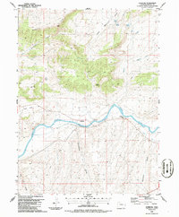
1986 Map of Sunbeam
USGS Topo · Published 1986About this map
Sunbeam stands as a small riverside settlement along the northern bank of the Yampa River during the mid-1980s. This Colorado landscape is defined by its dramatic topographic shifts, moving from the winding river valley up toward the prominent Godiva Rim and the Bald Mountain Basin. The map captures a high-desert terrain marked by numerous ephemeral drainages and landmarks that speak to the region's ranching and water-management history, such as Thornburg Draw and multiple Pump stations along the riverbank.
Find a feature on this map
24 named features on this map. Tap any name to fly to it.
Don’t see what you’re looking for? This feature index may not catch every label — zoom into the map to look around manually.
Map Details
Editions of this 1986 Sunbeam Map
This is the sole edition of this map. No revisions or reprints were ever made.
Other maps of this area

1907 · White River
USGS Topo · 1:125,000

1910 · White River
USGS Topo · 1:125,000

1954 · Vernal
USGS Topo · 1:250,000

1958 · Vernal
USGS Topo · 1:250,000

1958 · Maybell
USGS Topo · 1:62,500

1958 · Citadel Plateau
USGS Topo · 1:62,500

1960 · Vernal
USGS Topo · 1:250,000

1960 · Elk Springs
USGS Topo · 1:62,500

1960 · Lone Mountain
USGS Topo · 1:62,500
1979 · Rangely
USGS Topo · 1:100,000