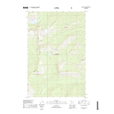
2020 Map of Sunburst Lake
USGS Topo · Published 2020About this map
Sunburst Lake and the towering peaks of the Swan Range dominate this high-elevation landscape within the Flathead National Forest. This remote Montana wilderness is defined by its dramatic relief, where deep drainages like Cannon Creek and Little Salmon Cr are carved between jagged summits such as Oreamnos Peak and Stadium Peak. The topography is a record of primitive access, showing established routes like the Lion - Palisade and Smith - Little Salmon trails that navigate the steep passes. The boundary between Lake Co and Flathead Co runs through the southwestern portion of the map near Owl Peak, marking a divide in this roadless backcountry. For those tracing the geography of the Northern Rockies, the map provides precise placement of alpine features like Palisade Lake and the Lion Greek Pass.
Find a feature on this map
25 named features on this map. Tap any name to fly to it.
Don’t see what you’re looking for? This feature index may not catch every label — zoom into the map to look around manually.
Map Details
Editions of this 2020 Sunburst Lake Map
This is the sole edition of this map. No revisions or reprints were ever made.
Other maps of this area

1936 · Silvertip
USGS Topo · 1:96,000

1942 · Silvertip
USGS Topo · 1:125,000

1955 · Choteau
USGS Topo · 1:250,000

1957 · Choteau
USGS Topo · 1:250,000

1958 · Choteau
USGS Topo · 1:250,000

1962 · Choteau
USGS Topo · 1:250,000

1965 · Condon
USGS Topo · 1:24,000

1965 · Sunburst Lake
USGS Topo · 1:24,000
1965 · Thunderbolt Mountain
USGS Topo · 1:24,000

1965 · Swan Peak
USGS Topo · 1:24,000