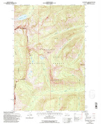
1994 Map of Sunburst Lake
USGS Topo · Published 1996About this map
The Swan Range crest provides a natural divide in this high-altitude landscape of the northern Rockies. The map documents the protected interior of the Bob Marshall Wilderness and the Flathead National Forest, focusing on a region defined by dramatic vertical relief and glacial hydrology. High peaks like Oreamnos Peak and Stadium Peak overlook a complex network of drainages, including Gorge Creek and Little Salmon Creek. This survey, updated in the mid-1990s, illustrates the limited human footprint in the area, restricted to a few established paths such as the route through Lion Creek Pass and the Spotted Bear Rd at the northern edge. Significant interior landmarks include Sunburst Lake and the smaller Palisade Lake, which mark the headwaters of the region's steep mountain streams.
Find a feature on this map
22 named features on this map. Tap any name to fly to it.
Don’t see what you’re looking for? This feature index may not catch every label — zoom into the map to look around manually.
Map Details
Editions of this 1994 Sunburst Lake Map
This is the sole edition of this map. No revisions or reprints were ever made.
Other maps of this area

1936 · Silvertip
USGS Topo · 1:96,000

1942 · Silvertip
USGS Topo · 1:125,000

1955 · Choteau
USGS Topo · 1:250,000

1957 · Choteau
USGS Topo · 1:250,000

1958 · Choteau
USGS Topo · 1:250,000

1962 · Choteau
USGS Topo · 1:250,000

1965 · Condon
USGS Topo · 1:24,000

1965 · Sunburst Lake
USGS Topo · 1:24,000
1965 · Thunderbolt Mountain
USGS Topo · 1:24,000

1965 · Swan Peak
USGS Topo · 1:24,000