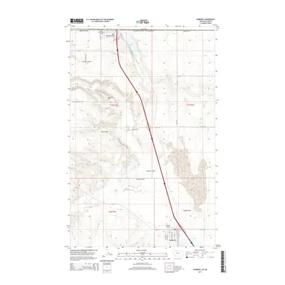
2014 Map of Sunburst
USGS Topo · Published 2014About this map
Sunburst and Sweet Grass anchor this northern Toole County landscape, where the High Plains meet the international boundary. This 2014 survey details a region defined by its role as a cross-border gateway, centered around the commerce and transport corridor connecting Montana to Canada. The terrain is characterized by a series of dramatic geographic features including Jerusalem Rocks, which rise above the surrounding drainage networks of Wolf Coulee and Sunburst Coulee. Smaller local routes like Farbo Farms Ln and McAlpine Rd crisscross the plains, serving the agricultural and ranching operations that have long sustained this frontier community. The presence of both Ross International Airport at the border and Sunburst Airport to the south underscores the area's continued strategic importance for regional aviation and logistics in the modern era.
Find a feature on this map
29 named features on this map. Tap any name to fly to it.
Don’t see what you’re looking for? This feature index may not catch every label — zoom into the map to look around manually.
Map Details
Editions of this 2014 Sunburst Map
This is the sole edition of this map. No revisions or reprints were ever made.
Other maps of this area

1909 · Cut Bank
USGS Topo · 1:125,000

1912 · Cut Bank
USGS Topo · 1:125,000

1939 · Sunburst
USGS Topo · 1:62,500

1954 · Shelby
USGS Topo · 1:250,000

1958 · Shelby
USGS Topo · 1:250,000

1960 · Cut Bank
USGS Topo · 1:250,000

1963 · Cut Bank
USGS Topo · 1:250,000

1964 · Cut Bank
USGS Topo · 1:250,000
1968 · Hillside Colony
USGS Topo · 1:24,000
1968 · Mountain View School
USGS Topo · 1:24,000