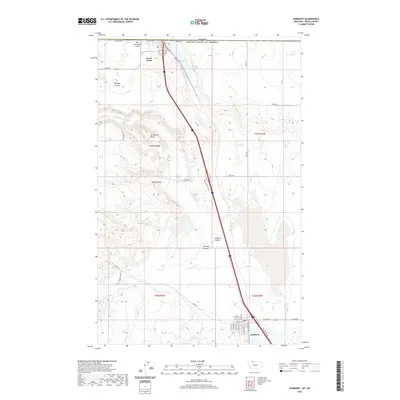
2020 Map of Sunburst
USGS Topo · Published 2020About this map
Sweet Grass and Sunburst anchor this Toole County landscape along the international boundary, where the High Plains meet the Canadian border. The map documents a classic northern Montana corridor, dominated by a north-south transportation artery that parallels Railroad St and the historic rail line through the heart of the region. The terrain is defined by dry-land drainages such as Halfway Coulee, Wolf Coulee, and Sunburst Coulee, which carve through the high ground towards the border.
Find a feature on this map
32 named features on this map. Tap any name to fly to it.
Don’t see what you’re looking for? This feature index may not catch every label — zoom into the map to look around manually.
Map Details
Editions of this 2020 Sunburst Map
This is the sole edition of this map. No revisions or reprints were ever made.
Other maps of this area

1909 · Cut Bank
USGS Topo · 1:125,000

1912 · Cut Bank
USGS Topo · 1:125,000

1939 · Sunburst
USGS Topo · 1:62,500

1954 · Shelby
USGS Topo · 1:250,000

1958 · Shelby
USGS Topo · 1:250,000

1960 · Cut Bank
USGS Topo · 1:250,000

1963 · Cut Bank
USGS Topo · 1:250,000

1964 · Cut Bank
USGS Topo · 1:250,000
1968 · Hillside Colony
USGS Topo · 1:24,000
1968 · Mountain View School
USGS Topo · 1:24,000