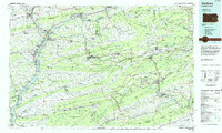
1984 Map of Sunbury
USGS Topo · Published 1985About this map
The confluence of the Susquehanna River and its West Branch at Sunbury anchors this mid-1980s look at the heart of Pennsylvania's anthracite region and the ridge-and-valley landscape. This map reveals a complex network of industrial towns and coal-country settlements like Shamokin, Mount Carmel, and Pottsville, all linked by the remaining lines of the Conrail and Delaware & Hudson RR systems. The terrain is defined by a series of long, parallel ridges including Mahanoy Mountain and Mahantango Mountain, which created natural barriers that funneled development into tight valley corridors.
Find a feature on this map
163 named features on this map. Tap any name to fly to it.
Don’t see what you’re looking for? This feature index may not catch every label — zoom into the map to look around manually.
Map Details
Editions of this 1984 Sunbury Map
2 editions found
Other maps of this area

1889 · Catawissa
USGS Topo · 1:62,500

1889 · Hazleton
USGS Topo · 1:62,500

1889 · Pottsville
USGS Topo · 1:62,500

1891 · Wilkesbarre
USGS Topo · 1:62,500

1891 · Hazleton
USGS Topo · 1:62,500

1891 · Pottsville
USGS Topo · 1:62,500

1891 · Lebanon
USGS Topo · 1:62,500

1892 · Catawissa
USGS Topo · 1:62,500

1892 · Lykens
USGS Topo · 1:62,500

1892 · Hummelstown
USGS Topo · 1:62,500