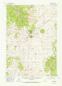
1958 Map of Sundance
USGS Topo · Published 1966About this map
Sundance sits at the heart of this mid-century topographic record, situated between the prominence of Sundance Mountain and Sugarloaf. The landscape transitions from the dense timber of the Black Hills to the high plains, revealing a pattern of early 20th-century settlement marked by family-named landmarks and rural institutions. Significant historical sites are noted, including a monument marking the Custer Expedition and the site of the first rural Methodist church in Wyoming.
Find a feature on this map
75 named features on this map. Tap any name to fly to it.
Don’t see what you’re looking for? This feature index may not catch every label — zoom into the map to look around manually.
Map Details
Editions of this 1958 Sundance Map
2 editions found

Other maps of this area

1898 · Sundance
USGS Topo · 1:125,000

1901 · Aladdin
USGS Topo · 1:125,000

1902 · Sundance
USGS Topo · 1:125,000

1903 · Aladdin
USGS Topo · 1:125,000

1905 · Devils Tower
USGS Topo · 1:125,000

1918 · Moorcroft
USGS Topo · 1:125,000

1954 · Gillette
USGS Topo · 1:250,000

1955 · Devils Tower
USGS Topo · 1:62,500

1955 · Gillette
USGS Topo · 1:250,000

1957 · Nefsy Divide
USGS Topo · 1:62,500