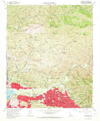
1966 Map of Sunland
USGS Topo · Published 1967About this map
Sunland and Tujunga sit at the mouth of the Big Tujunga Canyon, where the residential expansion of the mid-1960s meets the steep foothills of the Angeles National Forest. The map detail shows the transition from the dense street grids along Foothill Blvd to specialized land uses at the urban fringe, including the Lakeview Terrace Sanitarium and the Glen Haven Memorial Park. Massive flood control infrastructure dominates the southwest, with Hansen Dam and its spreading grounds managing the outflow from the canyons into the Tujunga Valley.
Find a feature on this map
114 named features on this map. Tap any name to fly to it.
Don’t see what you’re looking for? This feature index may not catch every label — zoom into the map to look around manually.
Map Details
Editions of this 1966 Sunland Map
3 editions found
Other maps of this area

1894 · Los Angeles
USGS Topo · 1:62,500

1896 · Pasadena
USGS Topo · 1:62,500

1896 · Santa Monica
USGS Topo · 1:62,500

1898 · Santa Monica
USGS Topo · 1:62,500

1900 · Pasadena
USGS Topo · 1:62,500

1900 · Tujunga
USGS Topo · 1:62,500

1900 · Los Angeles
USGS Topo · 1:62,500

1900 · Fernando
USGS Topo · 1:62,500

1901 · Southern California Sheet No. 1
USGS Topo · 1:250,000

1902 · Santa Monica
USGS Topo · 1:62,500