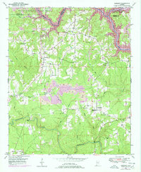
1949 Map of Sunlight
USGS Topo · Published 1978About this map
Sipsey Fork and Blackwater Creek anchor this landscape along the border of Walker and Winston Counties. The area is defined by a rural network of small communities and crossroads such as Marylee, Sunlight, and Burrows Crossroads. In the decades following the initial survey, the terrain underwent significant changes as evidenced by the numerous purple-shaded areas marking a Strip Mine and the expansion of Lewis Smith Lake in the northern reach.
Find a feature on this map
29 named features on this map. Tap any name to fly to it.
Don’t see what you’re looking for? This feature index may not catch every label — zoom into the map to look around manually.
Map Details
Editions of this 1949 Sunlight Map
3 editions found
Other maps of this area

1893 · Jasper
USGS Topo · 1:125,000

1949 · Cordova
USGS Topo · 1:24,000

1949 · Sipsey
USGS Topo · 1:24,000

1949 · Cold Springs
USGS Topo · 1:24,000

1949 · Jasper
USGS Topo · 1:24,000

1949 · Manchester
USGS Topo · 1:24,000

1949 · Sunlight
USGS Topo · 1:24,000

1950 · Manchester
USGS Topo · 1:24,000

1951 · Jasper
USGS Topo · 1:24,000

1951 · Cold Springs
USGS Topo · 1:24,000