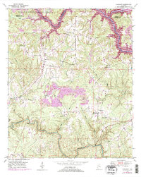
1949 Map of Sunlight
USGS Topo · Published 1997About this map
William B Bankhead National Forest defines the northern reaches of this map, where the complex terrain meets the winding waters of Sipsey Fork. The 1949 survey, updated with later aerial photography, reveals a landscape defined by the intersection of traditional rural communities and emerging industrial footprints. Significant Strip Mine operations are visible south of Sunlight, showing the scale of surface extraction in this part of Alabama. The map is a vital resource for genealogists, documenting a high density of country churches and burial grounds such as Herman Ch, Blooming Grove Cem, and the Shady Ridge Ch Cem. Along the lower portion of the sheet, the deep meanders of Blackwater Creek snake through the hills, while high points like the Lookout Tower provide vantage over the wooded ridges and small settlements like Marylee and Burrows Crossroads.
Find a feature on this map
31 named features on this map. Tap any name to fly to it.
Don’t see what you’re looking for? This feature index may not catch every label — zoom into the map to look around manually.
Map Details
Editions of this 1949 Sunlight Map
3 editions found
Other maps of this area

1893 · Jasper
USGS Topo · 1:125,000

1949 · Cordova
USGS Topo · 1:24,000

1949 · Sipsey
USGS Topo · 1:24,000

1949 · Cold Springs
USGS Topo · 1:24,000

1949 · Jasper
USGS Topo · 1:24,000

1949 · Manchester
USGS Topo · 1:24,000

1949 · Sunlight
USGS Topo · 1:24,000

1950 · Manchester
USGS Topo · 1:24,000

1951 · Jasper
USGS Topo · 1:24,000

1951 · Cold Springs
USGS Topo · 1:24,000