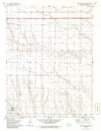
1979 Map of Sunny Slope Lake
USGS Topo · Published 1986About this map
The high plains of Gove County are defined here by a network of drainage systems cutting through the landscape. North Fork Big Creek and Big Creek dominate the central portion of the map, while the southern reaches are marked by the headwaters of East Spring Creek, West Spring Creek, and the North Branch Hackberry Creek. This 1979 survey captures the region as it transitioned into the modern era of transportation, with the Union Pacific railroad and Interstate 70 running parallel across the northern tier. Near the rail siding of Volts, the map details localized infrastructure such as Sewage Disposal Ponds and several irrigation wells. In the southwest, the recreational and water management feature of Sunny Slope Lake serves as a prominent landmark amidst the surrounding agricultural sections.
Find a feature on this map
18 named features on this map. Tap any name to fly to it.
Don’t see what you’re looking for? This feature index may not catch every label — zoom into the map to look around manually.
Map Details
Editions of this 1979 Sunny Slope Lake Map
2 editions found
Other maps of this area

1954 · Goodland
USGS Topo · 1:250,000

1955 · Scott City
USGS Topo · 1:250,000

1956 · Goodland
USGS Topo · 1:250,000

1957 · Goodland
USGS Topo · 1:250,000

1958 · Scott City
USGS Topo · 1:250,000

1972 · Orion NE
USGS Topo · 1:24,000

1972 · Gove
USGS Topo · 1:24,000

1972 · Orion
USGS Topo · 1:24,000

1979 · Midway Draw West
USGS Topo · 1:24,000
1979 · Grainfield
USGS Topo · 1:24,000