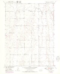
1949 Map of Sunnydale
USGS Topo · Published 1979About this map
Sunnydale Sch serves as the central landmark in this 1949 topographic study of Adams County, Colorado. The landscape is defined by the wandering path of Lost Creek, which carves through the undulating terrain of the Missouri River Basin. A significant piece of local irrigation history is preserved here in the form of an abandoned Canal, tracing a defunct route north of the creek. Numerous Windmill sites are mapped across the sections, indicating a reliance on groundwater for the agricultural operations that shaped this part of the High Plains. While largely rural, the map provides a clear look at the township and range divisions, specifically the boundary between T. 1 S. and T. 2 S., which organizes the sparsely settled territory during the post-war era.
Find a feature on this map
5 named features on this map. Tap any name to fly to it.
Don’t see what you’re looking for? This feature index may not catch every label — zoom into the map to look around manually.
Map Details
Editions of this 1949 Sunnydale Map
4 editions found
Other maps of this area

1890 · East Denver
USGS Topo · 1:125,000

1902 · Greeley
USGS Topo · 1:125,000

1949 · Sunnydale
USGS Topo · 1:24,000

1949 · Bennett
USGS Topo · 1:24,000

1950 · South Roggen
USGS Topo · 1:24,000

1950 · Keenesburg
USGS Topo · 1:24,000

1950 · Prospect Valley
USGS Topo · 1:24,000

1950 · Roper School
USGS Topo · 1:24,000

1951 · Keenesburg
USGS Topo · 1:24,000

1951 · Prospect Valley
USGS Topo · 1:24,000