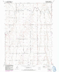
1949 Map of Sunnydale
USGS Topo · Published 1992About this map
Sunnydale Sch stands as a focal point in this high plains landscape of Adams County, documented during a mid-century survey of the Missouri River Basin. The terrain is defined by the ephemeral drainages of Lost Creek, West Sand Creek, and Sand Creek, which cut through the agricultural sections of the eastern Colorado prairie. An important artifact of early 20th-century water management is visible in the Henrylyn Canal (Abandoned), which once served this semi-arid region's irrigation needs before falling into disuse. Numerous windmills dot the sections, indicating the critical reliance on groundwater for livestock and homesteads in an area where surface water is seasonal. The presence of a significant Pipeline running through the southern reaches reflects the infrastructure development supporting the broader energy and utility networks across the plains during the late 1940s.
Find a feature on this map
7 named features on this map. Tap any name to fly to it.
Don’t see what you’re looking for? This feature index may not catch every label — zoom into the map to look around manually.
Map Details
Editions of this 1949 Sunnydale Map
4 editions found
Other maps of this area

1890 · East Denver
USGS Topo · 1:125,000

1902 · Greeley
USGS Topo · 1:125,000

1949 · Sunnydale
USGS Topo · 1:24,000

1949 · Bennett
USGS Topo · 1:24,000

1950 · South Roggen
USGS Topo · 1:24,000

1950 · Keenesburg
USGS Topo · 1:24,000

1950 · Prospect Valley
USGS Topo · 1:24,000

1950 · Roper School
USGS Topo · 1:24,000

1951 · Keenesburg
USGS Topo · 1:24,000

1951 · Prospect Valley
USGS Topo · 1:24,000